|
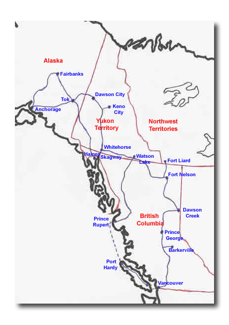
Thursday, July 22 - Haines to Kluane Lake If I don’t write this Journal, sort the photos, and get the website ready each day, it soon gets out of hand and I have to run a marathon to catch up. So it was last night and this morning, about 5 hours in all. Of course, that then means we’re late getting away and late getting into the next campground. So here it is after 11pm again. We left Haines late morning, driving up the Haines Highway, which winds through the Chilkat River valley. The river is wide, with plenty of sandbars in its delta and is the site of the Chilkat Bald Eagle Preserve, a 48,000 acre sanctuary that is the seasonal home to over 3,500 bald eagles. When the weather turns cold and rivers start to freeze, the bald eagles leave their more northerly homes and travel here to feast on the late run of salmon. The most popular spot is called the Council Grounds, and the best viewing is mid-October to January, at which time they return to their homes. At this time of year, the numbers aren’t so prolific – we saw a grand total of two. Leaving the Chilkat River valley, the Haines Highway climbs to its summit at Chilkat Pass. This pass offered a third path to the Yukon goldfields from the coast, an alternative to the Chilkoot Pass from Dyea and White Pass from Skagway. After the pass, the highway descends towards Haines Junction. In a span of forty miles, we left Alaska, entered and left British Columbia, and entered the Yukon Territory. Tomorrow, we leave the Yukon and enter Alaska again. One interesting stop we made was at Rock Glacier Trail. Over countless years of winter freezing and spring thaws, the surface rocks on the mountain cracked and fell onto a glacier below. Rather than the glacier pushing rock ahead of itself as is usual with a glacier, this one carried the rock on top of itself. When the glacier died as a result of warmer temperatures, this huge river of rock was left behind. At Haines Junction, the Haines Highway ends, intersecting with the Alaska Highway. Haines Junction is home to one of three Catholic missions on the north Alaska Highway. It was built from an army quonset hut reclaimed from highway construction days. Certainly unique in appearance, it has the honour of being the most photographed church in the Yukon. Without a doubt, the highlight of the day was Kluane National Park. We watched a video at the Kluane National Park Visitor Centre in Haines Junction. On the road, there were beautiful views of mountains and glaciers as the highway paralleled the Kluane Ranges, a nearly unbroken chain of mountains up to 8,000 feet high. To the west of the Kluane Ranges are the St. Elias Mountains, not visible from the highway. These were named by Russian explorer Vitus Bering. As he approached the coastline in 1791, he saw a tall peak, and named it Mount St. Elias for the patron of Russia, as it was his feast day. There are 8 peaks over 15,000 feet in the St. Elias Mountains, including Canada’s highest peak, Mount Logan, at 19,545 feet. Along the highway in the distance were the largest meadows of fireweed we’ve seen yet – they covered the whole side of a number of hills. At the same time, one of the most shocking things we saw today was the number of dead trees. Over 2 million acres of Alaska’s spruce forests were infected by the spruce beetle in the 1990s, with dead trees a tell-tale reddish brown colour. As I type this, I’m listening to the wind-swept waves hitting the shores of Kluane Lake about ten feet from the trailer in the campground we’re staying at tonight. Kluane Lake is the largest lake in the Yukon Territory, and its blue-green waters are especially beautiful. Haines to Kluane Lake photos, click here. Friday, July 23 - Kluane Lake to Tok Lotsa driving today. About an eight hour drive, with six hours of actual driving interspersed with stops. Our first stop was at the Kluane Museum of Natural History in Burwash Landing. The museum features wildlife exhibits with dioramas depicting natural habitat. Also displayed are Native clothing, tools, and weapons. This was really interesting – one of the best stops we’ve made. Outside the museum was the world’s largest gold pan. Also outside was an exhibit on a local forest fire. The fire, which happened in 1999, commanded a lot of interest from the “outside”. The fire was kept pressed against the northern edge of Kluane Lake by winds blowing across the nearby glacier. The result was an oblong-shaped fire that was five times as long as it was wide. Shortly after entering Alaska is the southern boundary of the Tetlin National Wildlife Refuge. The 730,000 acre refuge offers a variety of habitat for both migratory and local wildlife. It is not a sanctuary, however, as hunting, fishing, and trapping are allowed. The Tetlin National Wildlife Refuge Visitor Center offers a viewing deck with spotting scopes and displays on wildlife and various interpretive programs. They give travelers an audio tape to listen to on the way through the refuge, and then deposit in the Visitor Center in Tok. This section of the highway featured lots of gravel sections that were so dusty that on one of them there was a tanker truck spraying water as it drove along. I’ve come to believe that Alaska dirt is dirtier than BC dirt, judging from the appearance of our car and trailer. When we stopped, the first thing we did was vacuum the whole inside of the trailer. And then there were the roller coaster sections. When a highway is laid on top of permafrost, the temperature on the roadbase changes. The permafrost adjusts by expanding and contracting, causing rolling heaves all along the highway. The result is that you have to keep slowing down for them. When you think it’s over, you speed up again, only to find your stomach in your mouth as you hit the next one. For Kluane Lake to Tok photos, click here. |
Haines to Tok
From Haines to Tok. Scroll down to read our Journal.
Haines to Kluane Lake photos, click here.
For Kluane Lake to Tok photos, click here.