|
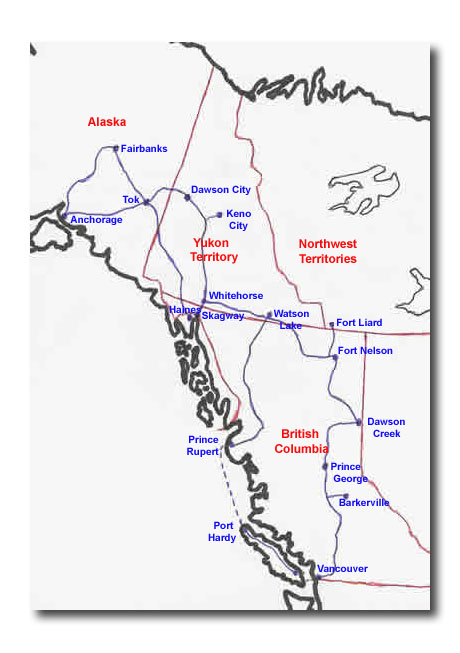
Wednesday, July 14 - Prince Rupert to Terrace As we were unloading from the ferry last night, the ramp was at an unusually high angle, presumably because it was low tide. One of the stabilizer bars at the rear corner of the trailer didn’t survive the bump as it hit the ferry deck. Also, the wind-up post at the trailer hitch wasn’t wound up quite high enough, so it hit the ramp, causing it to bend and shear its holding collar. I spent the morning getting this website ready to upload. I forgot to mention that much of the ferry ride was spent preparing the website as well. The things I do for my friends! Then we went into town to find a welder to repair the hitch post. Having dropped the trailer off, we then went to get an oil change (the machine shop that worked on the motor before we left advised us to get the oil changed after 500 and 1,000 miles, so we planned on getting it changed in Prince Rupert and Whitehorse). While that was being done, we went to an Internet café where I could upload these files, check my e-mail, and send my e-mail to you announcing this website. I’m still not totally in business yet, as my e-mail program isn’t set up to download my e-mail, forcing me to use webmail. When I dropped the car off for the oil change, I asked the mechanic to check on a rattling noise – I thought that the bolts had come loose on the running board on my side of the car. Turned out that the bolts on the brake calipers hadn’t been fully tightened and had worked loose enough to allow the rattling. I seem to have this thing with brakes. Fortunately, my guardian angel has been on the job. These unscheduled delays meant that a couple of the things we had wanted to do in Prince Rupert weren’t able to be done. We did, however, go to the North Pacific Historic Fishing Village, a restored fish cannery that’s a National Historic Site. It was really interesting, with a guide giving talks and actually cranking up the canning line, an ingenious multi-stage series of equipment that takes a whole fish and cleans it, cuts it, cans it and seals it. We then drove to Terrace, where Gerald Hoffman was born and raised. We drove along the Skeena River to get there. The drive reminded me of the portion of the Sea to Sky Highway from Horseshoe Bay to Squamish, while the Skeena reminded me of the Fraser River. The day was beautiful, warm and sunny, which added to the scenery. I don’t imagine it’s quite so nice when the weather is cold, windy, and rainy. The salmon are running, and so all along the way there were campers and trailers parked at the side of the road and tents along the side of the river and on sandbars. The RV park we planned to stay at tonight was full, forcing us to go to a municipal campground. It turned out to be even better, much like a provincial campground, and gave us the opportunity to try out the capacity of the trailer’s inverter and battery bank. Worked like a charm – even though we had no electrical hookup, we used the microwave and recharged the batteries on my computer, camera and camcorder. Anne made dinner for us – literally. Last summer she made a few dozen jars of pesto. To everyone else’s annoyance, she insisted on doing this on the morning we were to leave for the homeschool camp. Tonight, we were very grateful for last summer’s inconvenience. After dinner, it was marshmallows and smores around the campfire. Geoffrey was particularly entertaining, as he set marshmallow after marshmallow on fire. Char-grilled he called it. We came to the conclusion that we need two bags of marshmallows – one for Geoffrey and one for all the rest of us. After about six inedible attempts, he did finally succeed in roasting a reasonable specimen. Prince Rupert to Terrace photos, click here. Thursday, July 15 - Terrace to Meziadin Lake There was a good RV service centre in Terrace, so we dropped the trailer to have the rear stabilizer replaced. In the meantime, we drove to Nisga’a Memorial Lava Bed Park. This lava flow is thought to be the most recent volcanic eruption in Canada, about 250 years ago. It covers an area about 10km long and 3km wide, all created by a volcano about 350 feet high. The eruption destroyed two villages, killing more than 2,000 people. Alongside the lava bed is Vetter Falls, which we paid a brief visit before continuing on to Lava Lake. We stopped there for a swim. The water was very cold first time in, but you got used to it, especially after being quickly warmed in the 30 degree sunshine. The sun wasn’t to last, however, as we picked up the trailer and headed towards the Cassiar Highway. Following the Skeena River until the junction of the Yellowhead and Cassiar Highways at Kitwanga, the road wound right alongside the river for much of the way. Turning north on the Cassiar Highway, the rain started to come down. It poured and made for a slower and much longer drive than what we were hoping for. We pulled into Meziadin Lake Provincial Park and had a late dinner once again. The provincial parks are truly beautiful. They are however, not serviced – no electric, water or sewer hookups. With a full tank of water and our inverter, we can go for two nights before we need more water or to recharge the batteries. Terrace to Meziadin Lake photos, click here. Friday, July 16 - Meziadin Lake to Itsuk Rain continued to fall this morning. We left the trailer at Meziadin Lake and drove the Glacier Highway to Stewart – Hyder, about a one hour drive. I was aware from reading The Milepost, the mile-by-mile guidebook of the highways approaching the Yukon and Alaska, of the Bear Glacier near the twin cities of Stewart, BC and Hyder, Alaska. I didn’t really think it warranted naming a highway after just one glacier. I was soon to be apprised of just why it was named Glacier Highway. It was one of the most spectacular stretches of highway I’ve ever driven. The only other highway that compares is the one between Banff and Jasper. On that one, the glaciers are occasional and, other than the Columbia Icefield, quite distant from the highway, whereas on the Glacier Highway, the road is right at the base of the mountains, and glaciers are on virtually every mountain along the way. The Bear Glacier flows right into a lake. We didn’t see it happen, but the glacier calves (i.e. drops chunks off) into the lake. The road was paved to the Canada – US border. Then, at the grubby little town of Hyder (population 102) the pavement ended and, because of the rain, it was mud. I imagine that when the weather changes and it isn’t mud, the road is just dust. Or snow – they get 35 feet of it in winter! It wasn’t exactly an auspicious first visit to Alaska. To mark the occasion, we bought a fridge magnet saying “Alaska State Bird” underneath a mosquito. We then drove about 30 km up a rough road – quite rocky in places – to the Salmon Glacier, the fifth largest glacier in North America, and the largest accessible by road. It was huge, about 10km long. On the way back down, we stopped at Fish Creek. The U.S. Forest Service has constructed a 600 foot long boardwalk about 15 feet above the creek, where you can see grizzly and black bears feeding on the spawning salmon. We were really disappointed that we didn’t see any bears, as they’d been coming out at dusk lately. We did, however, see lots of salmon and a young bald eagle feasting on a salmon carcass. At about 5 o’clock, we started out on what we thought would be a three hour drive to our next stop – Iskut. Because of road construction and lots of gravel stretches, it turned out to be 4-1/2 hours, most of it rainy. We were all a little frazzled and glad to pull into camp. Meziadin Lake to Iskut photos, click here. Saturday, July 17 - Itsuk to Watson Lake “Gravel begins northbound. Narrow, winding road with potholes and washboard next 26 km.” You don’t look forward to these entries in The Milepost. Especially when they are frequent – it makes for a long driving day. Rain continued today for most of the day, so as well as gravel, potholes, and washboard, you get mud. Still, the scenery is beautiful. There wasn’t anything particularly spectacular, but lots of pretty lakes, streams, and rivers. We stopped for a break at the side of the road at Simmons Lake, which was pastoral and serene. Jade City, named for the huge jade deposits found near here, provided another stop. The Cassiar Mountain Range supplies about 75 percent of the world’s jade supply. If you want to try your hand in another endeavour, a sign in the jade store said that they were selling their gold mining claims at $15,000 per 125 acres. They were too busy working the jade to have time for gold! And it’s not that the gold isn’t lucrative – the largest nugget ever found in B.C. was near here and it weighed 72 ounces! Arriving at Watson Lake, we surveyed the city in about a minute and decided to go to the Northern Lights Centre, a dome theatre featuring a show on the aurora borealis. Although they’re there all the time, you don’t see much of them in the summer because it’s too light. It didn’t get dark until about 11:30 tonight. Iskut to Watson Lake photos, click here. |
Cassiar Highway
From Prince Rupert to Watson Lake via the Cassiar Highway. Scroll down to read our Journal.
Prince Rupert to Terrace photos, click here.
Terrace to Meziadin Lake photos, click here.
Meziadin Lake to Iskut photos, click here.
Iskut to Watson Lake photos, click here.