|
Wednesday, August 11 -– Watson Lake to Muncho Lake We gave our trailer a bath this morning, its first since we started the trip. Nice and clean, we left Watson Lake only to hit a gravel section. Fortunately, it wasn’t too dusty and the trailer still looks respectable. The next couple of hours weren’t eventful, and then we approached a car stopped by the side of the road. Slowing down, we saw a buffalo by the side of the road. It was a large male, and once we had our photographs, we continued on. As we came down a hill and rounded a curve at the bottom, there was a whole herd of buffalo right at the side of the road. And judging from the condition of the road, they had just crossed it. Although we didn’t count, there must have been about fifty – males, females, and calves. After leaving the buffalo, we soon reached Liard Hot Springs. This is a naturally occurring hot springs, ranging in temperature from (108 – 128 F). It’s outdoors in its natural setting. You approach it on a ½-mile walk along a boardwalk through a warm marsh. The marsh has “hot fish” that have adapted to the lukewarm stream that feed on the rich algae there, as well as some “tropical” plants. Until fifty years ago, this was known as Liard Tropical Valley. The hot springs itself bubbles at one end of the bathing pools which are long and narrow and have changing rooms, a wooden deck, and steps into the pool along one side. The further away from the bubbling end you go, the cooler it gets. At the far end a cold stream feeds in. The bubbling end is too hot to stand in. In fact, about 1/3 of the pool is too hot. The hot water bubbles up and forms a hot top layer on the pool, and if people aren’t stirring it up by moving around, it gets hotter and hotter. It was really a treat. We arrived at Muncho Lake to be greeted by swarms of gnats. We brought bug jackets/hoods that have seen very limited use on the trip. The original plan was for the jackets to keep mosquitoes at bay, but surprisingly, they haven’t been a problem. But as we get further south again, we’re noticing more bugs; when we cleaned off the trailer at Watson Lake, the front of it was plastered with bugs. Here at Muncho Lake, we had to bring Duncan inside the trailer. He’s been sleeping outside the whole trip, but here, he was being attacked. Muncho Lake is beautiful. It’s striking colour, as well as that of many other mountain lakes and streams, is the result of glacial silt, so finely ground that it’s called “rock flour.” It remains suspended in the water rather than sinking to the bottom and reflects light, mainly the blue-green part of the spectrum, to our eyes. For Watson Lake to Muncho Lake photos, click here. Thursday, August 12 -– Muncho Lake to Fort Nelson A few years ago, the BC government set aside the Muskwa-Kechika, a 4.4 million hectare wilderness area. Known as the “Serengeti of the North”, it’s the largest intact, unroaded wildnerness area south of the 60th parallel. One of the most striking features of this area is the mountains – some of them look like they’re all rock, without anything growing on them. They appear to be folded, and there are giant washes of gravel and boulders fanning out at their bases. You’d expect them to be running into a river, but they’re dry. I’d imagine spring runoff to be torrential. Shortly after leaving Muncho Lake, we came upon a small herd of Stone sheep. Stone sheep (northern BC and southern Yukon), dall sheep (Yukon and Alaska), bighorn or mountain sheep (Rocky Mountains), and are all similar, but get smaller the further north they go. We came across them in a couple of places along the highway. They were licking the road surface, perhaps for the salt. End of the day’s journey was at Fort Nelson, a population centre of over 5,000 and home to the largest natural gas processing plant in North America. After processing here, the gas is sent through an 800-mile pipeline to Vancouver. We visited the Fort Nelson Heritage Museum, which has excellent displays of pioneer artifacts. It has quite an extensive selection of equipment used in the construction of the Alaska Highway. One of the displays was an ad recruiting men to work on the Alaska Highway. The ad reads: “Men will have to fight swamps, rivers, ice and cold. Mosquitoes, flies and gnats will not only be annoying but will cause bodily harm. If you are not prepared to work under these conditions, do not apply.” For Muncho Lake to Fort Nelson photos, click here. Friday, August 13 -– Liard TrailWe visited the Northwest Territories today. Click here to join us! Saturday, August 14 -– Fort Nelson to Fort St John We got lost today! On the way from Fort Nelson to Fort St John is a side trip to Sikhanni Chief Falls. We dropped the trailer at a turnout on the highway and started up the gravel road. About 8 kilometres in, the road branched and we took the right-hand fork. After driving for about 10km on this road, we came not to the water falls but to a small natural gas plant – obviously we were on the wrong road. Backtracking to the fork, we took the other road. All of a sudden, the road was paved! It was obviously not maintained, so there were potholes here and there. We followed the road until we came to barriers blocking the way to where a bridge had previously been. We had read in The Milepost that there was a single lane bridge, so we assumed that it had been written the year before and the bridge had been taken out since then. No problem – quite a number of enterprising people had gone off the road, forded the creek, and gone up the other side. We followed their lead without incident and continued on for another few kilometers until, lo and behold, we arrived back on the highway! We later found out that this was a section of the old Alaska Highway that had been replaced, but at the time, we were expecting to arrive at the trailhead for a hike to some water falls, not the highway. To make matters worse, when we came out on the highway, we had no idea which way we should be heading. We drove for 20 kilometres, thinking that we might be going in the right direction, about to turn around and head the other way, until we espied our trailer at the side of the road. What a bizarre experience! We stopped at a road stop and got the right directions. Ten miles back on the highway to the turnoff we had been looking for, another 10 miles on a gravel road, and then a one-mile hike put us on 150-foot cliffs overlooking the 98-foot high Sikhanni Chief Falls. This was truly spectacular, and worth the hassle we’d been through to get there. The rest of our trip was uneventful, and we pulled into a nice RV park in Fort St John. This is a really pretty city of about 17,000 people. Established as Rocky Mountain Fort in 1794, Fort St John is the oldest white settlement in mainland BC. It was the headquarters for troops and civilians building the Alaska Highway in the eastern sector, while Whitehorse was the headquarters for the western sector. An immense natural gas and oil field was discovered here in the 1950s, making Fort St John the oil capital of BC. We enjoyed sitting around a campfire, only the second time we’ve been able to be able to do so on our trip. For Fort Nelson to Fort St. John photos, click here. Sunday, August 15 -– Fort St John to Dawson CreekMost of the day was taken up in a side trip to Hudson’s Hope, location of the WAC Bennett Dam on the Peace River. I had seen the dam being built on a holiday with my parents in 1963. It was amazing to see the finished product. The dam and generating station form the largest hydroelectric facility in BC Hydro’s system, providing about 1/3 of the electricity it provides to its 1.6 million customers. Williston Reservoir, the largest fresh-water lake in BC, was created by the dam, and is 225 miles long and 500 feet deep. Its water level fluctuates depending on inflows from melting snow and rain and the amount of water drawn through the turbines in the generating station. Water is drawn into ten 15-foot in diameter intake gates, plunging into giant steel tubes called penstocks at about 30kmh. The plummeting water drives turbines inside the underground powerhouse, 3 football fields long and carved out of solid rock. As the turbines spin, they turn the rotors in the generators, converting mechanical energy into electrical energy. Above the powerhouse, the switchyard sends the electricity onto five transmission lines to northeaster and central BC and the Lower Mainland. The water is then fed into two tailrace tunnels that exit at the base of the dam. If it is necessary to remove water from the reservoir without running it through the turbines, gates are opened to let water into the 2300-foot spillway. The end of the spillway curves up at a 30-degree angle, much like a ski jump, and the water shoots out 300 feet into the middle of the river downstream of the dam. It has only been necessary to open the spillway 8 times in the 35 years the dam has been operating, and it is spectacular to see. Ten years in the planning, the actual construction of the dam took five years and employed nearly 5,000 people at its peak. One of the largest earthfill dams in the world, it’s 600 feet high, 800 metres wide at the base and 9 metres wide at the top. The amount of fill in the dam would build a wall 9 feet wide and 12 feet tall from Vancouver to Halifax. The Visitor Centre had some really interesting hands-on displays on how electricity is generated. They also had a few short films on the building of the dam that really gave a sense of what a phenomenal achievement the building of this dam was. The best thing of all is that there is a road along the crest of the dam that you can drive across to a view point on the other side. Of course, we took advantage of this opportunity. It was amazing to drive along slowly, from one side of the road to the other, stopping if we wanted to to look over the edge of the dam to the river 600 feet below. We’ve had such a variety of experiences on this trip, and the visit to the dam was one of the highlights. For Fort St John to Dawson Creek photos, click here. |
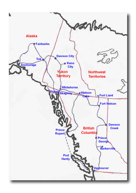
Watson Lake to Dawson Creek
Scroll down to read our Journal from Watson Lake to Dawson Creek.
For Watson Lake to Muncho Lake photos, click here.
For Muncho Lake to Fort Nelson photos, click here.
For Fort Nelson to Fort St. John photos, click here.
For Fort St John to Dawson Creek photos, click here.