|
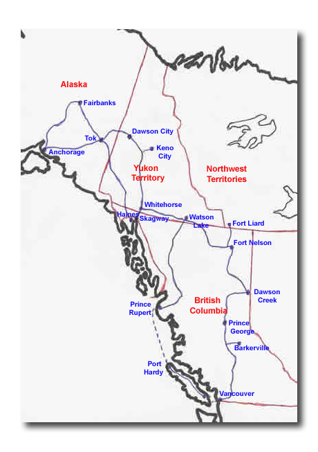
Tuesday, August 3 -– Tok to Dawson City Although the distance from Tok to Dawson City is only 300km, this grueling drive took 6 hours plus stops. The first half is along the Taylor Highway, a misnomer in our minds. It would more accurately be called the Taylor Logging Road. It was the worst road we’ve encountered so far – gravel, potholes, washboard, and very steep climbs up into the mountains. Narrow, unfenced curves hugged the mountain, giving way to steep gullies and canyons far below. Our speed ranged between 30 – 60km per hour in this section. For about a 27-mile stretch, we were in the burnt remains of the forest fire that raged here about three weeks ago. As far as the eye could see were black sticks – the charred remains of spruce trees. The sky was hazy, as smoke from nearly a dozen smoldering fires still went up into the air. We passed by one fire that we could see flames, just a quarter mile off the highway. Unless a forest fire threatens a populated area, it is left to burn. After 100-200 years, the spruce trees dominate the forest, choking off other vegetation. Lightning strikes and starts a fire, burning the trees but often leaving a clump at the very top of the tree. This clump contains the cones, which fall to the ground and start new trees. Before the new trees take hold, other vegetation sprouts up, and attracts voles and other small animals. These, in turn, attract predators like foxes and wolves. And on it goes, the food chain developing as the forested area regrows. So a forest fire is seen as a good thing. Along the way, we stopped for a late lunch at beautiful downtown Chicken, which consists of about 3 establishments manned by a population of 37 hardy souls. One of these establishments is a trading post where local miners still trade gold for supplies. Chicken was supposedly named by early miners who wanted to name their camp Ptarmigan, but couldn’t agree on the spelling, so settled on Chicken instead. In and around Chicken were gold dredges, reminders of activities that were carried on until about 50 years ago. Most of the mining is now done by small operations doing placer mining. The road continues to climb steeply until the Canada/U.S. border is reached. Clocks jump ahead an hour. Shortly after the border is crossed we reach the highest point of the highway at 4,515 feet. The change in the road from the U.S. to Canada is dramatic. The Top of the World Highway is 50% wider than the Taylor Logging Road. The gravel is compacted and sprayed with a chemical that keeps the dust down and hardens the road, a process known as chip sealing. The result is a semi-hard road, inbetween coarse asphalt and gravel. Unlike the American stretch, there were guard rails around the corners. Our pace picked up to 80km unless we were climbing a hill. One short stop was made to follow a porcupine scurrying at the side of the road when we passed. It hid in a bush, but was still visible. Cute little critter, and no, porcupines cannot throw their quills. The Top of the World Highway is aptly named. It is one of the most beautiful stretches of road I’ve ever been on. At the summit, you can stand and turn 360 degrees, a spectacular vista of mountain ranges. From here to Dawson City, the highway wound its way along a ridge, valleys on each side, and bounded by mountain ranges in every direction. What goes up must come down, and come down we did, winding our way towards Dawson City. The first hint of approaching the city came as we rounded a corner and saw the Yukon River far below us. About 15km and a few thousand feet in elevation later, we were at the river’s edge, waiting for the free 24-hour ferry to carry us across the river into Dawson City. We arrived on the other side a little after 10pm, checked into the RV park, had dinner, and went to bed, anticipating tomorrow’s activities in Dawson City. For Tok to Dawson City photos, click here. |
Tok to Dawson City
Tok to Dawson City. Scroll down to read our Journal.
Tok to Dawson City photos, click here.